Better Farming with Laser Aided Drainage
The use of GPS positioning and laser technology in land surveying has grown immensely since it was introduced in the 1960s. What was once a series of manual measurements and calculations has evolved into an automated process that is faster, more accurate and that can be applied in real time from moving vehicles and specialized machinery. The original application for survey has evolved in laser enabled land leveling and laser enabled drainage tile installation. This evolution has come from the combination of several new technologies.
Lasers, LiDAR, GPS and RTK
The initial laser scanning equipment was basic; consisting of cameras, projectors, and lights. Around 1985, these simple scanners were replaced with LiDAR systems — high-quality scanners that use laser beams and shadowing to collect data relating to objects and surfaces. Global positioning system (GPS) inputs were later incorporated between two individual points to serve as a way to input the vertical and horizontal control.
This has evolved into a concept called real-time kinematics (RTK) that can produce 3D mapping for any terrain regardless of the obstacles. Real-time kinematics combines GPS satellite data with a ground station in the same location as the user to broadcast a correction via radio or cellular data connection. These three-dimensional images can be used for detailed analysis even for hard to reach places like caves or dense forests. How RTK synthesizes an accurate location using GPS can be visualized in the following diagram.
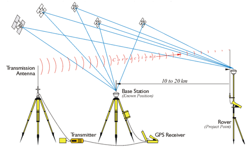
Image source: https://www.everythingrf.com/community/what-is-real-time-kinematics
We have included a video in the sources below from the Geospatial World YouTube channel [1] below that also illustrates GNSS RTK concepts.
Farm drainage tiling
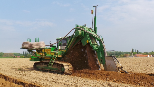
One modern use for this technology is in the proper placement of agricultural drainage tile for removing excess moisture from farmland. Good drainage improves yields and decreases erosion for most farmland. It also can make marginal land more accessible and productive. During drainage tile installation, the RTK-GPS contour of the field is measured in real time against the optimal tile drainage slope as the tiling machine moves through the field. Agricultural tiling machines use the elevation data from an RTK-GPS receiver to automatically output signals to the hydraulics controlling the tile plow to define the correct drainage grade specific to the field contour.
Agriculture drainage tiling is a modern application merging laser liDAR, GPS and RTK into an automated process that make crop production more efficient. A Successful Farming story [5] highlighting the benefits of drainage tile showed estimated yield gains 10 to 45 bushes per acre for corn and 4 to 15 bushels per acre gains for soybeans. The story includes other useful estimates for some of the other costs and tax benefits of tile installation.
The Sources section at the bottom of this article also includes several other videos showing modern farmland drainage tiling details and installation views how these technologies combine to efficiently apply slope controlled drainage to to improve farming production. We have also included a few links showing modern heavy duty trenchers and plows that use RTK and GPS for precision tile drainage installation.
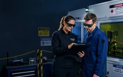
How Laser Safety Certification can help
At Laser Safety Certification, we have laser safety courses and Laser Safety Officer (LSO) certification programs to make sure your team are correctly using lasers and your customers are protected. For more information about industrial laser safety, check out our courses for Industrial Laser Safety and Industrial LSO certification.
We also have laser safety certification courses for Cosmetic or Medical/Healthcare and Veterinary laser users. We provide Laser Safety Officer certification courses to help organize your company laser safety program. We base this training on the current OSHA Technical Manual sections that apply to laser hazards. We can also provide your company with laser safety kits and bundles to help your LSO administer your laser safety program to protect your team as well as your customers.
Click here to enroll your company to get started today. Or check out our FAQ section for common answers about our courses, certification options and kit offerings, and get started by enrolling your company today. You can always email us at info@lasersafetycertification.com if you want more information about how we can help your business use lasers safely while protecting your employees and your customers.
Sources / References
[1] Geospatial World video illustrating GNSS RTK concepts: https://www.youtube.com/watch?v=Xm53w-BwuQw
[2] AgPhD YouTube channel video on Farmland Tiling Basics: https://youtu.be/Xm53w-BwuQw
[3] Visual overview of how farmland pattern tiling works: https://www.youtube.com/watch?v=fxqSWRrKOMY
[4] Millennial Farmer YouTube channel post showing tiling machine operation up close and inside the tiling machine cab: https://www.youtube.com/watch?v=quFbSgLTE3o
[5] Successful Farming story on the benefits of improved drainage: https://www.agriculture.com/farm-management/finances-accounting/put-drain-tiling-under-the-financial-microscope
[6a] Inter-Drain equipment (as shown above in Millennial Farmer video): https://inter-drain.com/index.php/en/
[6b] Inter-Drain laser specific equipment details: https://inter-drain.com/index.php/en/products/laser-control
Image source: Inter-Drain 1824DWT