Modern LiDAR and GPS Usage in Land Surveying
For as long as people and nations have claimed ownership of land, accurately measuring and defining a piece of dirt has been important. The profession of surveying dates back several centuries to the Roman era; land surveyors in this time were known as “agrimensores” [7] or by the Latin name “gromatici.” [8]
Surveying in Ancient Times
The Egyptians performed some of the earliest recorded land survey operations; they measured land for the purpose of taxation, building the pyramids and defining boundaries between adjacent properties. Egyptian surveyors used a technique involving a knotted rope and thus were known as “rope stretchers” . [1]
Surveyors in ancient Babylon used inscribed limestone tablets set into the land as boundary stones. Early examples from around 1200 BC include the property description, the surveyor, the owner, along with the ownership history. [1] Some of these early boundary marker examples included detailed curses intended for anyone disturbing the stone.
The Greeks adopted many Egyptian survey techniques and advanced the science of geometry and invented the first pieces of surveying equipment. Both the Romans and the Greeks used the human foot to make (highly inaccurate) measurements. But the 6th Century BC, the Greeks had developed more sophisticated instruments called the “groma” [3] to survey straight lines and right angles, and the “dioptra” [4] (similar to a theodolite or transit) for measuring angles. Greek surveying details are documented in many surviving technical treatises, with the most complete being Hero of Alexandria’s Dioptra from the 1st century BC. [2]
The Romans adopted these earlier methods and also diversified the survey profession into different fields for land surveying needs for boundary recording, for civil engineering needs for longer distances and elevations or roads and aqueducts, and for military purposes to protect (and also attack) strategic geographies or structures.
A 16th-century mathematician, Leonard Digges, invented the theodolite. [5] A theodolite is basically a telescope mounted on a swivel placed on a tripod and measures both horizontal and vertical angles. Theodolites offer very accurate results measured in seconds of the 360-degree circle (degrees/minutes/seconds). A 2-second theodolite is extremely accurate for objects up to 2,000 feet away. Most errors at this distance are human in nature due to improper leveling or hasty readings. A prism is used to reflect infrared light back to the instrument, so early theodolites required 2 surveyors.
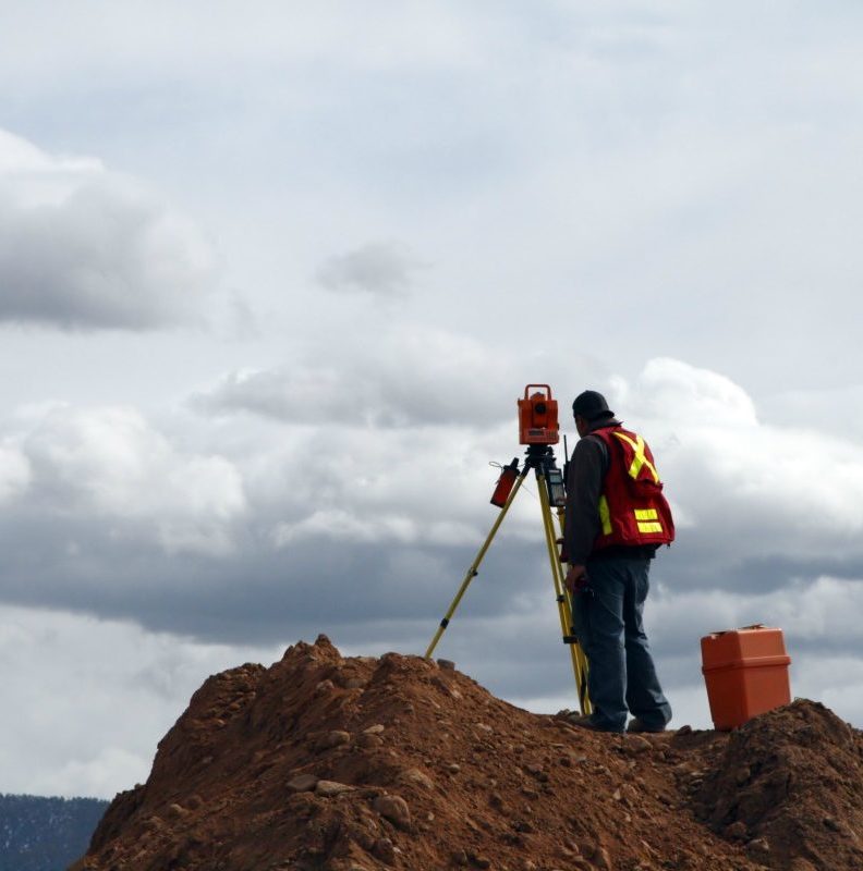
Modern Surveying and LiDAR
Modern electronic theodolites only require one surveyor since the person holding the prism can operate the laser remotely. This makes street and highway surveying safer and doesn’t block traffic. Laser surveying is much more accurate and is especially useful in uneven terrains. They do not work for under water or water surface measuring so ultrasonic tools are used instead.
Whereas modern electronic measuring tools use one laser beam to accurately measure the distance between 2 points, 3-D laser scanners use 50,000 beam scans to create and map a 3-D model. These tools are especially useful for small spaces and tunnels and for outdoor construction project planning. LiDAR (Light Detection and Ranging) produces very detailed images in short periods of time. LiDAR technology is becoming more commonly used in land surveying and is even more common for building and structure surveys.
GPS and Drones
Global positioning systems make land surveying exponentially quicker and more accurate. What once took teams of surveyors weeks can now be done in one day. GPS surveying is not limited by line-of-sight problems since all that is required is an area open to the sky. GPS systems are lightweight and easily transported. Data collection is quick and can be communicated wirelessly.
Will drones replace human surveyors? It’s too soon to know but certainly they can get to remote places very easily. They are currently used to assist surveyors with mapping large areas or capturing characteristics of inaccessible locations.
A Geospatial World video [6] outlines 5 key benefits of modern drone-assisted surveys; listing that:
- they are time saving compared to manual or multiple composite surveys
- they are cost effective when compared to traditional aerial methods
- they offer accessibility enabling measurement of hard to reach locations
- they give accuracy of the measurements taken
- they give increased safety for the operating team
References
[1] PointToPoint survey blog: https://www.pointtopointsurvey.com/2009/10/land-surveying-in-ancient-times-egypt-greece-and-rome/
[2] Erenow Ancient History & Civilization topic: https://erenow.net/ancient/ancient-perspectives/6.php
[3] Wikipedia Groma topic: https://en.wikipedia.org/wiki/Groma_(surveying)
[4] Wikipedia Dioptra entry: https://en.wikipedia.org/wiki/Dioptra
[5] Wikipedia Theodolite entry: https://en.wikipedia.org/wiki/Theodolite
[6] Geospatial World YouTube channel, Benefits of Drones: https://www.youtube.com/watch?v=vuh9OX2E6ek
[7] LiDAR Magazine, Agrimensores: https://lidarmag.com/2009/03/17/agrimensores/
[8] Wikipedia Gromatici entry: https://en.wikipedia.org/wiki/Gromatici


Thank you for sharing this informative article of yours. I hope there’s a lot of people can read this article and be guided.
sofiacox31@gmail.com
Thank you for sharing this informative article about the GPS survey. I hope there are a lot of surveyors who could read this and be guided accordingly.
Comments are closed.